METAR Board
The METAR board is a time series display of weather conditions. There are two formats for the board: condensed and expanded.
Condensed view
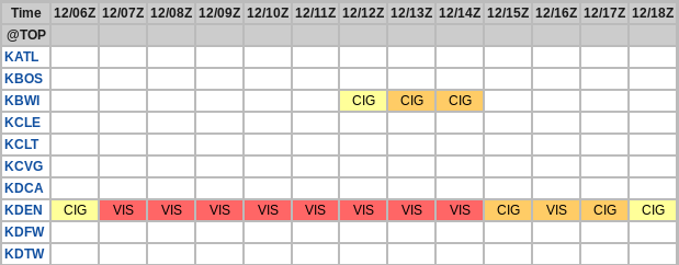
The condensed view lists any number of stations along the vertical axis and time along the horizontal axis (See Fig 1). Each box (hourly observation) is color coded based on the level of the hazard. Green represents no hazard, yellow minimal hazard, red significant hazard and purple major hazard. The letters in the box represent the cause of the hazard. They are as follows:
- Ceil - Ceiling
- Vis - Visibility
- Wx - Weather (thunderstorms, freezing rain)
- WSpd - Wind speed
- WGst - Wind gusts
There could be multiple hazards but only the top one from this list is shown.

The cutoffs for each color are shown in Fig. 2. The default criteria use the flight category cutoffs

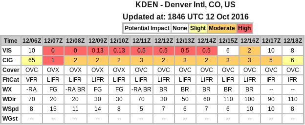
For more detailed site information, click the station identifier. This will open the expanded view for each site. In the expanded view, each weather condition is listed along the vertical axis (See Fig. 3). These are:
- Vis - Visibility in miles
- Ceil - Cloud ceiling in 100s feet
- Cover - Cloud cover: CLR, FEW, SCT, BKN, OVC
- FltCat - Flight category: VFR, MVFR, IFR, LIFR
- Wx - Weather
- WDir - Wind direction
- WSpd - Wind speed in knots
- WGst - Wind gusts in knots

URL Options
Here is a list of the URL options:
- ids=id[+id...] - Specifies the stations to retrieve data
- format={condensed|expanded} - Specifies the format of output as either condensed or expanded. The default is condensed.
- date=yyyymmddhhnn - This selects a specific date and time to display. ADDS saves a week of METAR data so this can be used to get older METAR data. The default is current.