Vietor Aviation
HOME
Aviation
Weather
WXP
ADVISORIES
SIGMET
G-AIRMET
Center Weather
FORECASTS
Convection
Turbulence
Icing
Wind/Temps
TAFs
Avn Forecast Disc
OBSERVATIONS
Aircraft Reps Data
METARs
Radar
Satellite
TOOLS
Full Tool
Data API
Text Data Server
NEWS
News
Status
USER
Login
Settings
Go
METARs
METAR Home
Plot
Data
Board
Info
Imagery
Sat
Radar
Overlay
Highway
Road
County
Jetroute
FIR
View
User 1
User 2
User 3
User 4
CONUS
Northeast
Southeast
North Central
South Central
Northwest
Southwest
Alaska
Hawaii
Caribbean
Europe
South America
East Asia
Australia
Configure
Parameters Visible:
Temp
Wind
Alt
Vis
Wx
Cover
Ceil
Dew
Wgst
Id
Density
-1
0
+1
+2
All
Scale
1
1.25
1.5
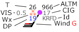
Decoded data
Include TAF
Valid time:
Weather Symbols Key
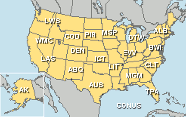
Regional METAR Plots
Click on site name to access regional plot
Request METAR data
IDs:
Format:
Raw
Decoded
Time:
most recent only
past 1 hours
past 2 hours
past 3 hours
past 4 hours
past 5 hours
past 6 hours
past 12 hours
past 18 hours
past 24 hours
past 36 hours
past 48 hours
past 72 hours
past 96 hours
past 120 hours
Include TAF
Show METAR board
IDs:
Search METAR Sites
ADDS Station Table
NCEI METAR Archive