Interactive Display
The interactive display shows three data types:
- US SIGMETs - SIGMETs issued for the CONUS.
- International SIGMETs - SIGMETs issued outside the CONUS.
- CWAs - Center Weather Advisories issued by the CWSUs.
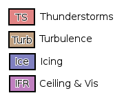
Each type of hazard is colored differently. The convective SIGMETs are filled red. The turbulence SIGMETs are brown. The icing SIGMETs are blue. Ash SIGMETs are gray. All SIGMETs have a red border.
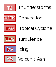
CWAs have the same fill color but the outlines and text are black rather than red so they can be distinguished from SIGMETs.
SIGMETs can be filtered by altitude range by adjusting the Top and Bottom selectors.
The SIGMETs and CWAs are all clickable to access the raw text of the product.
NOTE: Because of differences in encoding, the international SIGMETs only show the region or FIR that the SIGMET is valid. In some cases, a polygon can be decoded and resulting area shown. In most others, the SIGMET is only valid for a subset of the region shown. Multiple SIGMETs may be valid for the same area. PLEASE refer to the SIGMET text or go to the SIGMET data page to get all the SIGMETs in an area.
URL Options
Here is a list of the URL options:
NO HELPER urloptions